Check distances for simulated height
To simulate the horizon profile from roof level, Azimutis needs the horizontal distance to obstacles in the surveyed directions. Check distances lets you review proposed map outlines and correct missing or inaccurate features.
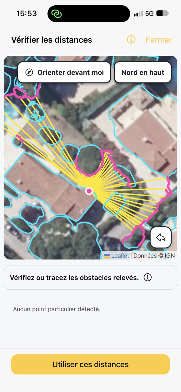
Open distance checking
Section titled “Open distance checking”- From Overview, open Simulate a different height.
- Enter roof height and check survey height.
- Tap Check distances. Outline estimation may already have started, depending on available information.
The map centers on the survey measurement position. Rays show directions corresponding to points in the original profile. Suggested outlines represent objects that may intersect those directions.
Check proposed obstacles
Section titled “Check proposed obstacles”Compare the map with the site:
- Check that the measurement position is where you stood.
- Identify the trees, buildings or other obstacles targeted during the survey.
- Check that proposed outlines actually follow those obstacles.
- Review rays crossing several obstacles: the first object intersected on the map is not necessarily the one responsible for the measured profile.
- Complete or correct outlines that do not match the actual site.
Automatic detection is not a certified distance measurement. Quality depends on the map, its alignment, visible objects and survey position.
Draw or correct an obstacle
Section titled “Draw or correct an obstacle”The screen asks you to check or draw the surveyed obstacles.
- One finger: trace the obstacle outline on the map. Release to save.
- Two fingers: pan or zoom the map.
- Undo arrow: undo the last manually drawn outline.
- Tap a ray: show the corresponding azimuth and elevation, depending on the selected ray.
Manual drawing may remain available if detection fails. No detected outline does not prove that no obstacle exists on site.
Check obstacles and distances
Section titled “Check obstacles and distances”The panel may indicate:
| Message | What to check |
|---|---|
| Missing distances | No usable obstacle was found in some directions; draw the surveyed obstacle where needed. |
| Obstacles to choose between | Several outlines intersect one ray: identify the correct obstacle. |
| Very close obstacles | A small position or outline error may produce a large difference in the simulated angle. |
| No particular issues detected | No particular check is flagged at this point; this does not automatically validate every outline. |
Orient the map
Section titled “Orient the map”Where available, Face my direction aligns the display with the phone’s orientation; North up restores a conventional north-facing view. This helps you orient yourself but does not replace obstacle checks.
Use the distances
Section titled “Use the distances”After checking rays and outlines, tap Use these distances to return to height simulation. Tap Calculate to compare at the desired height, then Apply this height if the results are suitable.
For directions still missing distances, the app may retain the original survey angle, limiting reliability in those sectors. Incorrect geometry can also produce misleading results even when the calculation succeeds.